Vandalism to pictographs opposite Nelson this summer was a sobering reminder of how vulnerable such sites are, even if they’re robust in other ways. The red ochre images in question survived for possibly hundreds of years before someone came along and splattered them with a paintball gun. As provincial authorities and First Nations decide what action to take, the Star examines what’s known about Kootenay Lake’s ancient aboriginal artwork.
Archaeological Record
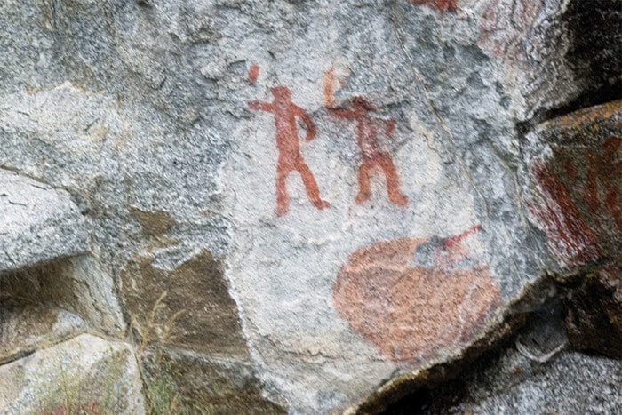
The desecrated pictograph, on a cliff face accessible only by boat, is one of about two dozen such rock paintings known around the lake. They are found on both the east and west shores of the north and south arms, but only two sites have been recorded on the West Arm, including this one.
Provincial archaeologist Al Mackie said he couldn’t share inventory records out of concern for protecting other sites from vandalism and unauthorized digging and collecting — a concern reflected in provisions of both the Heritage Conservation and Freedom of Information acts — but the record on this particular rock image is slim.
Their data indicate the site was first recorded by John Corner, author of Pictographs (Indian Rock Paintings) in the Interior of British Columbia (1968). Although his book included several Kootenay Lake pictographs, this wasn’t one of them. Nor was it mentioned in Exploring BC’s Pictographs: A Guide to Native Rock Art in the British Columbia Interior, by Simon Nankivell and David Wyse (2003).
However, during a pictograph inventory of Kootenay Lake by Richard Baravelle between 1977 and 1979, it was designated DiQh-2. With the provincial archaeologist’s blessing, Baravelle revisited ten sites recorded by Corner and Harlan I. Smith of the Canadian Museum of Civilization and discovered 14 new ones. He also learned that a few had been destroyed.
Corner suggested most surviving pictographs in BC were painted 200 to 300 years ago, based on lichen growth and weathering, and that the most recent ones on Kootenay Lake dated to the 1860s. While Baravelle agreed the oldest in the region dated back no more than 300 years, he believed two sets were painted as late as the 1890s.
While none of the above literature tried to interpret DiQh-2, in general Mackie says pictographs had many functions, from depicting well-known stories to serving as territorial markers to playing a role in puberty rituals.
Mackie says the colour comes from naturally-occuring ferrous oxide mixed with various binding agents. “It’s common to have fish eggs in the mix and possibly something like bear grease or fish oil,” he said. “The pigment is very durable because it’s essentially rust. The binding agents lock up pretty tight.”
It’s similar, he added, to the isinglass extracted from fish eggs by European master painters 300 to 500 years ago. “They might also use egg whites. When it cures, it’s very long lasting.”
That nearly all pictographs on the shores of interior lakes are above high water marks was no accident, Corner wrote: “This fact is strikingly evident on Kootenay Lake where all panels except three are 20 to 25 feet above low water and easily seen from the lake … The conclusion is that the painters realized that paintings vulnerable to wear and erosion of high water would soon disappear.”
Mackie doubts that river and lake levels were significantly higher in the past. So how did the artists reach their rock canvasses? By scaling the cliffs or building scaffolding, he suggests.
Since the vandalism came to light last month, Mackie has been investigating restoration options, researching the materials that go into paintball paint and trying to understand how it might interact with the rock art.

“The problem is the chemistry needed to remove the paint is sometimes very different than the chemistry involved in making rock art in the first place. It might not be difficult to separate the paint from the rock with modern chemicals. I just don’t know if that’s the case here.”
If the paint is water soluble, it may be best to let rain take care of it, Mackie said, adding that the decision-making will also be influenced by the fact the spot is difficult to reach.
Anonymous Artist
Both the Ktunaxa and Sinixt First Nations are known to have created pictographs.
The Sinixt’s traditional territory includes the Arrow Lakes, Slocan Lake, and Christina Lake, while Ktunaxa territory comprised the East Kootenay — but the two overlapped on Kootenay Lake. So how can we tell who was responsible for the pictograph in question?
Baravelle cited certain characteristics he believed were more likely to belong to either the Ktunaxa or the Sinixt, and suggested both painted pictographs on Kootenay Lake, but didn’t speculate about the ones on the West Arm.
However, local Sinixt say their ancestors were responsible for them — and all other pictographs in West Kootenay.
“Right where the Nelson transfer station is located and all along the waterfront by Cottonwood Creek was a seasonal Sinixt village site. That’s why the pictographs are across from the Nelson area,” said Dennis Zarelli, communications and media liaison for the Sinixt. “Kaslo was also a seasonal village site and that is why there are pictographs across from there too. The same goes for Slocan and Christina Lake.”
The Ktunaxa don’t claim authorship of the pictographs, but don’t deny it either — they simply don’t discuss it publicly, according to Melanie Sam, director of traditional knowledge and language for the Ktunaxa Nation Council. “It’s just not something we would divulge,” she said.
Sam, based in Cranbrook, said she was aware of the recent damage to the pictograph but has not seen it herself. Regardless, she expressed her “complete outrage, shock, and disbelief that something like this could happen. It’s very devastating.” Sam added that she isn’t aware of any other cases of this type of vandalism.
Who painted the pictograph may be a moot point as far as restoration is concerned, for on this point the two groups have similar views.
Zarelli said Sinixt elders have asked the damaged pictograph be left as is, “as what has happened is now part of the story, and nothing can change that. Let it be.”
Sam said she has previously received direction from elders that pictographs were meant to fade over time, “so we wouldn’t do anything to preserve them — we wouldn’t put a shellac coat overtop or anything. But in the case of vandalism, it may be handled differently.”
Sam said a decision will be made following a meeting of her advisory council — a group of elders — scheduled for November 7.
While the Ktunaxa Nation Council has heard from the provincial archaeology branch concerning the pictograph, the Sinixt, who aren’t officially recognized by the BC government, have not.
However, Zarelli said earlier this year they signed a sharing agreement with the province and obtained nearly 2,500 pages of archaeological data on their traditional territory, including information on pictographs.
“This data is sensitive as it provides detailed information on how to access many of these cultural sites and if made public knowledge could lead to further abuses and crimes against Sinixt cultural heritage sites,” Zarelli said.
At the same time, he said they are developing signage for sensitive areas that they hope will deter such actions.
Vandalism Rare
The authors of the books on BC pictographs mentioned above were aware that publicizing their locations might have adverse, unintended consequences, but concluded the benefits outweighed the risks.
Corner wrote that in addition to natural factors such as flood, slides, fungus, seepage and weathering, “Whenever site locations are indicated by highway markers the inevitable and systematic destruction of the paintings begins.”
Nankivell and Wyse said they “wrestled with the dilemma of providing detailed site location information,” as they were concerned about vandalism and theft, but Corner gave detailed directions, and “from what we can tell, it did not result in the loss of any sites.” Yet they noted a number of pictographs that had been vandalized or vanished.
Mackie, the government archaeologist, said while pictograph vandalism is rare, it happened most infamously on Standing Rock near Keremeos, where pictographs on a large stone were covered over with modern graffiti. In the 1970s the rock was cleaned by conservators from the Royal BC Museum — only to be swiftly covered over again, with less benign paint types than appears to be the case for paintballs.
The vandalism to the pictograph opposite Nelson was noted on September 24 by Claire de la Salle of Friends of Kootenay Lake and amateur photographer Alistair Fraser, who maintains a popular blog and website, but may have happened at least a month earlier.
The Heritage Conservation Act provides fines and jail time for anyone convicted of damaging archeological sites. RCMP Cpl. Michael Stefani said Monday that police have no leads.